Roger Smith, a retired educator from Romney, WV, began the operation of Romney Flying Service in 1970 and located the operation on the Mexico Farms Airfield in the large hangar on the west side of the end of runway 35. This operation would perform functions under contract with the West Virginia Department of Agriculture for the next twenty plus years.
The following is a quote from the guiding operations manual: “Romney Flying Service, Inc. is engaged in aerial detection survey work under contract to the WV Department of Agriculture. These operations include flights for the purpose of spotting insect and disease infestations (Oak Wilt), Gypsy Moth defoliation, and others.” Utilizing single engine light aircraft (primarily Piper PA-18 Super Cub aircraft), the company’s area of operations constituted the entire state of West Virginia. The normal flight crew consisted of a pilot, employed under contract to Romney Flying Service, and an observer or spotter who was employed by the WV Department of Agriculture. Flight operations would always be conducted under visual meteorological conditions (VMC) at 500 feet AGL, except as provided by an FAA certificate of waiver. Each year the company sought and received a waiver under FAR 91.79(c) which allowed for operations to a minimum of 200 feet over any person on the surface.
Over the years the company’s operations changed but the prime mission was the Oak Wilt diseased tree surveillance. In later times multi-flora rose coverage plottage was undertaken, then later with the invasion of the Gypsy Moth, surveys were made as to location, damage, and then as observer of the actual spraying to help stop the defoliation. Chase aircraft would aid in locating and assuring that the proper spray plots were covered. Other mission requirements entailed aerial surveillance for locating illegal growing of marijuana and on rare occasions a fisherman head count on the South Branch of the Potomac River. Flights would be made from the Petersburg Gap northward to the confluence with the North Branch of the Potomac with a count of the observed anglers tabulated.
Raymond Walker, living just behind what was known as the Oak Wilt hangar, served as the maintainer of the aircraft fleet and with his wife, Freda, served Roger Smith as dedicated co-workers in keeping the aircraft in flying condition. Raymond, along with his wife, maintained the company records and kept the fleet of airplanes in clean, bug free condition following each day’s activity. Also, under Raymond’s oversight were two local youngsters, Chad Hamilton being the prime helper and gofer in the upkeep of the fleet. The required 100 hour and annual inspections were performed by Bill Pancake, and later by Greg Teeter.
In 1976 the four pilots employed were: Harold Armstrong – Chief Pilot, Jim Abe, Bob Armstrong and Bill Armstrong. These four flew a Bellanca Citabria – N53985 and three Piper PA-18-150 Super Cubs – N4079Z, N4239Z, N4460Z. Throughout the summer at least one of these aircraft would be dispersed to airfields at Hamlin, Parkersburg, Hurricane, or Elkins. Other outlying operation sites were Fairmont, Clarksburg, Summersville, Craigsville, Bartow, and Martinsburg. Spotters who plotted Oak Wilt diseased trees were: Denver Kidner, Fred Wieneke, Harold Wieneke, Harry Kelso, Steve Raschella, Bill Rubin, Lucian Harriet, Mark Sturgill, Tim Bucher, Keith Sines, Len Armstrong, and others.
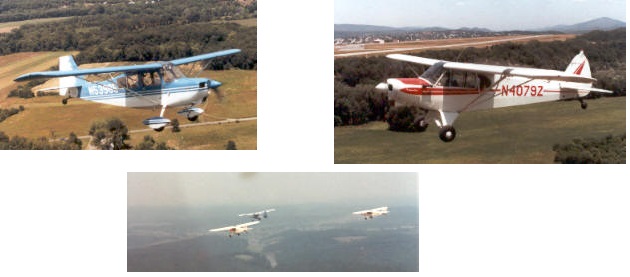
Top Left: Citabria. Top Right: Piper Super Cub. Center: Formation inbound for work on Oak Wilt tree surveillance.
The commonly available topographic maps known as U.S. Geological Survey 7 minute quadrangle charts, called ‘quads’ were used. These maps, highly detailed, cover a four-sided area whose latitude and longitude span a distance of 7 minutes, or 1/8th of a degree on the earth’s surface. Depending on longitude and latitude, such a quadrangle covers from 49 to 70 square miles. More than 54,000 of these charts are necessary to map the conterminous 48 states, with approximately 400 needed to cover the state of West Virginia.
A typical Oak Wilt surveillance mission would begin at 7:30 am and end at 4 in the evening. A mid-day lunch and /or fuel break would always be flexible depending on location from a suitable landing or refueling site. Two to four quads would be covered depending on distance to travel and the amount of plotting to be accomplished. In the earlier years the Department of Agriculture, through the Department of Natural Resources would follow up the aerial plotting of the diseased trees with a variety of procedures to kill or isolate the problem area. A ground crew of from four to eight persons would perform this function. This would entail totally girdling the trunk close to the ground or to inject a killing agent in the root area. This undertaking was an effort to protect the timber industry in the state, primarily to preclude the shipment of diseased trees overseas and therefore the spread of the disease world wide. After years of these attempts the efforts were given up as being not feasible since the spread of the disease via spores in the air and by root grafts from tree to tree was totally unpredictable and in the end uncontrollable to any suitable degree by human efforts.
To aid the ground crews in this joint air and ground effort, the early years saw a concerted effort to plot the affected site on the quad map and at the same time to visually identify the site by dropping rolls of toilet paper on the tree displaying the orange/brown discoloration of the leaves in the top of the trees. Oak makes up over 50% of the timber in the state of West Virginia. Refined efforts in this marking of the bad trees saw the use of rolled adding machine paper tossed out to identify the site. This free falling projectile was more efficient but it was still a challenge to place the roll where desired considering wind, terrain, and location to nearest trail or road to access from the ground. On one occasion an effort was made to place a paper roll on the west side near the top of a mountain in the eastern panhandle. With a strong west wind and with the contour of the mountain the paper would be dropped over the site only to stay airborne up and over the ridge. At least five attempts resulted in failure – each time the effort looked good only to see the unfurling paper trail just go up and over the ridge line to somewhere on the downwind side. In giving up the attempt one was left wondering how in the fall hunting season a hunter, coming upon the site of this array of white paper scattered about the oaks would react to the sight. Perhaps it would be to visualize a disgruntled local taxpayer, after being exposed to an IRS audit, pursuing the Infernal Revenue Agent through the woods hurling roll after roll of unfurling adding machine paper while chasing the agent east bound in the hope he would never be seen again.
Harold Armstrong had the more interesting experience with the use of adding machine paper when marking trees. This situation involved a WV state trooper accosting him after the fact when the operation was adversely reported by a local individual. Harold and his spotter were marking a diseased tree near a busy highway. Unfortunately, the drop was a bit late resulting in part of the paper trail transiting over part of the roadway. A passing motorist, undoubtedly shocked and intrigued by the sight, reported the incident to the WV State Police. The aircraft’s tail number was included in the report enabling the trooper to locate the aircrew later in the evening at their motel. The spotter, Tim Bucher, a Glenville, WV pre-law student, was first approached and diligently detailed the airborne procedure and purpose of throwing out rolls of adding machine paper while flying quite low and slow over West Virginia real estate. The trooper looked perplexed and responded, “You have to be sh_____ me!” Tim then directed the trooper to his pilot and Harold affirmed the details previously given. Looking the part of a grizzled old timer and with the vocabulary to match, the trooper may have surmised that this could be an individual who had spent a lifetime defying the laws of gravity. Walking away and shaking his head the trooper terminated the “investigation.” One muses if the written report was ever concluded and if so did the guardian of West Virginia law have the fortitude to show it to anyone at the home office.
Newly assigned spotters with no exposure to this type of operation needed a briefing or indoctrination as to emergency procedures. It went something like this:
We are going to be flying low and slow over terrain that more often than not will look hostile especially if we have to make an emergency landing. I have been flying this type operation for years and have had no trouble in relying on the good old Lycoming 150 hp engine in keeping us airborne. However, should we have engine failure or, the Lord forbid, we should run out of petrol, and we are unable to make a cleared area here is what I want you to do. If touchdown in the forest canopy is our only option I will land straight ahead in a level attitude at as slow a speed as possible but short of a stall and the wings will shed as we decelerate through the tree tops hoping that our nose avoids any sturdy oak or other hardwood tree greater than two inches diameter that will not break off quickly as we gradually come to rest in our fuselage cocoon on the forest floor whereupon we exit and walk away smiling – Any questions? Yes, you can hide your eyes by looping your arms over your face while you relax to the best of your ability while bracing yourself for a slightly different kind of landing. Now let’s go fly!
In order to get to a quad and begin work the pilot would identify the most prominent land mark, compute a heading and simply dead reckon to the location. In some cases that was not easy since many quads had no towns, no railroads or paved roads, or any prominent point on which to orient. When arriving on the quad it would then be difficult to have a definite point at which to begin. Sometimes it was necessary to use a previously worked adjacent quad for orientation. Quads could be worked many ways, across the map east and west, from top to bottom or north and south, or in many cases simply flying the contour of the mountains which in most cases are aligned 030-210 degrees. In other cases where there were several open fields with splotches of forest one would simply cover it in sections of forestation. When available each crewmember would have a map but in most cases the pilot used the quad for initial orientation, and then handed the map to the spotter. Then as reversals were called for the spotter would simply touch the right or left shoulder of the pilot to make the appropriate 180 degree turn. At times the pilot would be aware that the turn was late and would query the spotter as to how it was possible to plot a tree if not on the map. A normal answer was, “Sorry, turn left, it is a bit drowsy back here.”
Mexico Farms, as the home base, and Elkins, as the most used temporary duty location, were the most heavily used for take offs and recoveries. Ironically, they are both located in a fish bowl adjacent to a river and most susceptible for early morning fog. On many a morning when fog in the local area would delay the working day, the crews would have to wait out visual conditions. When the sun would come through the fog but the visibility remained limited, takeoffs would be made down runway 9 using that best of God made artificial horizons, the good old morning rising sun, as the point of reference. The pilot would simply hold heading, making sure the sun remained in the same point, while climbing straight out until arriving on top of the fog bank. However, at Elkins one could not undertake an individualized special departure procedure since the FAA Flight Service Station was located on site. However, the use ‘Special VFR’ clearance through coordination with Elkins Radio was used on numerous occasions for both take off and recovery.
Fred Wieneke, a spotter who flew for several years, had the habit of, upon deplaning at the end of a long day, loosening up his muscles by hitting the ground and doing a few push ups. The Elkins FSS personnel viewing this frequently would chide Fred about kissing the sweet earth after having escaped death again on his return from another hair raising flight experience.
When flying to and from these many locations the possibility existed of getting on top of an undercast if one was not too alert. A self made emergency procedure for this eventuality was to proceed to the Kessel VOR atop Patterson Creek Mountain (ESL 110.8) at 3500′. A heading of 034 degrees would lead to Eugene Woodworth’s grass strip at Burlington. At 80 mph a letdown at 700’/minute for 5 minutes would place the aircraft over the landing strip. Assuming the pilot was in the clear by this time a landing could be accomplished at Burlington, or by holding the same heading a low level back flight to Mexico Farms could be accomplished. Illegal, to be sure, but self satisfying to have on hand nevertheless.
* * * * *
